In our June Xpresso-4X newsletter, we wrote about Giraffe, a web-based software application that unifies mapping, 3D modeling, and analytics data into a single platform ideal for urban design and building development.
Giraffe.build
Built on accurate GIS data and maps, with the ability to filter data layers that inform decision-makers, architects, and planners, Giraffe enables users to create and test concepts with smart tools that understand spatial relationships and site contexts.

Giraffe is an interesting new cloud-based BIM 2.0 tool focused on the pre-design, planning, and urban design phases of urban and suburban development.
Users can create design concepts and automatically calculate key metrics, showing real-time impacts at every stage. Additionally, Giraffe supports algorithm-driven design (AAD), where users can configure and edit custom algorithms to explore multiple design scenarios in minutes.
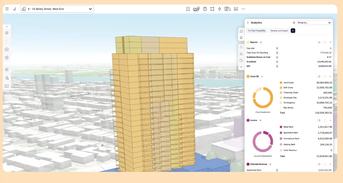
Giraffe helps architects and planners work faster with calculations that provide insights for all design iterations. There is also a formula builder that can be applied to every design variation. And clear visuals of data help the storytelling process, which is critical to buy-in with stakeholders.
For Architects
Giraffe helps architects execute detailed site analysis and master planning studies all in one tool. Typically, architects rely on utilizing multiple tools, especially with the numerical data that is associated with master planning studies, such as various area calculations. Giraffe promises a seamless integrated workflow that combines area calculations and 2D and 3D modeling all in one environment.
Giraffe in action. In our Xpresso-4X newsletter, we noted that Boston architects CBT Architects were testing Giraffe, as well as other leading architecture firms in the United States, Europe, and beyond. Giraffe itself is from Australia.
But what makes Giraffe most interesting to use is that it integrates data from map services, tapping their data via API connections and integrations. Giraffe itself is built on a map of the world.
This means architects can specify their project by address and bring up any combination of data layers associated with that address, including zoning, parcels, contours, transport, et cetera.
Giraffe features basic drawing tools so you can draw directly on the map with accuracy, including grid snaps, direct dimensional inputs, drawing layers, and rich graphical options. Each 2D shape can be extruded into building levels to create 3D buildings.
Giraffe can also import and export in various formats for interoperability, including soon IFC for BIM model interoperability. Using GeoJSON at its core, Giraffe is both human and machine-readable by GIS tools, Python, and JavaScript. It can handle import/export formats like DXF, OBJ (CAD Mesh), STL (CAD Mesh), GLTF/GLB (3D format), and other formats, including image and PDF.
Popular Uses
Interested readers can review videos on popular use cases, such as Design Feasibility, Precinct Planning, and Public Engagement & Story-telling.
Born in Australia
Giraffe was founded in 2018 and is based in Sydney, Australia, with staff in the United States. It was co-founded by CEO Rob Asher, who previously specialized in design technology at Cox Architecture in Sydney, Australia. Asher was reportedly interested in fusing and blending architectural design, urban analytics, and environmental insights into a unified application that could allow architects and designers to evaluate and visualize city and project concepts.
Users can try Giraffe for free and can scale up to three different pricing plans (subscriptions) from Core at 45.00 USD per month per single user, to Teams at 125.00 USD per month per user, to bespoke Enterprise licensing.
